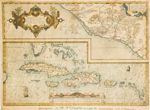
Early Carribbean Map. OCullanae, Americae Regionis, Descriptio..Hispaniolae, Cubae, Allarumqe Insualrum Circumiacientium Delineatio, From Ortelius, Theatrum Orbis Terrarum (1570): Early Dutch Map of Caribbean/Mexico, 1579 edition. Hand colored, with manuscript notations to the margins, old repairs. In double sided glass frame. Attractive hand colored copper engraved map from the seminal atlas of the 16th century, depicting the Caribbean, South Florida and west coast of Mexico with remarkable detail and accuracy for its time. Margins trimmed, sheet size 20" x 14.75", framed.
Price Realized: $350
Share or Email This Lot
View all Maps Lots in this Auction
View all Lots in the Fine Art & Antiques Auction
Price Realized: $350
Share or Email This Lot
View all Maps Lots in this Auction
View all Lots in the Fine Art & Antiques Auction
The Cobbs Auctioneers
Noone Falls Mill, 50 Jaffrey Road, Peterborough, New Hampshire 03458 USA
+1.603.924.6361
Copyright © 1996-2025 All rights reserved.
Auction Calendar |
Collecting |
American Furniture and Decorative Arts |
European Furniture and Decorative Arts |
Fine Art |
Asian Arts |
Sporting |
Ethnographic Arts |
Rugs and Carpets |
Books and Ephemera |
Jewelry |
Auction Results |
Buy |
Sell |
Catalogues |
Consignments |
Appraisals |
Our People |
About The Cobbs |
Contact | Conditions of Sale |
Legal |
Privacy


