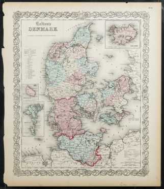
Colton's Denmark, 1855/1856. Hand colored map from JH Colton's first edition 'Atlas of the World', issued in 1855/1856. Beautifully intricate and accurate map showing towns, rivers, roads, mountains, etc., with inset maps of Iceland, Bornholm and the Faroe Islands. Decorative border, three column page on "The Kingdom of Denmark" on the reverse, visible accessible in double glass frame. Page, 15" x 17 1/4", with chips to border, small tear in top margin, fading. See photos for condition.
Price Realized: $100
Share or Email This Lot
View all Maps Lots in this Auction
View all Lots in the Spring Sporting Auction + Fine Art and Antiques Auction
Price Realized: $100
Share or Email This Lot
View all Maps Lots in this Auction
View all Lots in the Spring Sporting Auction + Fine Art and Antiques Auction
The Cobbs Auctioneers
Noone Falls Mill, 50 Jaffrey Road, Peterborough, New Hampshire 03458 USA
+1.603.924.6361
Copyright © 1996-2025 All rights reserved.
Auction Calendar |
Collecting |
American Furniture and Decorative Arts |
European Furniture and Decorative Arts |
Fine Art |
Asian Arts |
Sporting |
Ethnographic Arts |
Rugs and Carpets |
Books and Ephemera |
Jewelry |
Auction Results |
Buy |
Sell |
Catalogues |
Consignments |
Appraisals |
Our People |
About The Cobbs |
Contact | Conditions of Sale |
Legal |
Privacy


